
Map of Minnesota Territory.
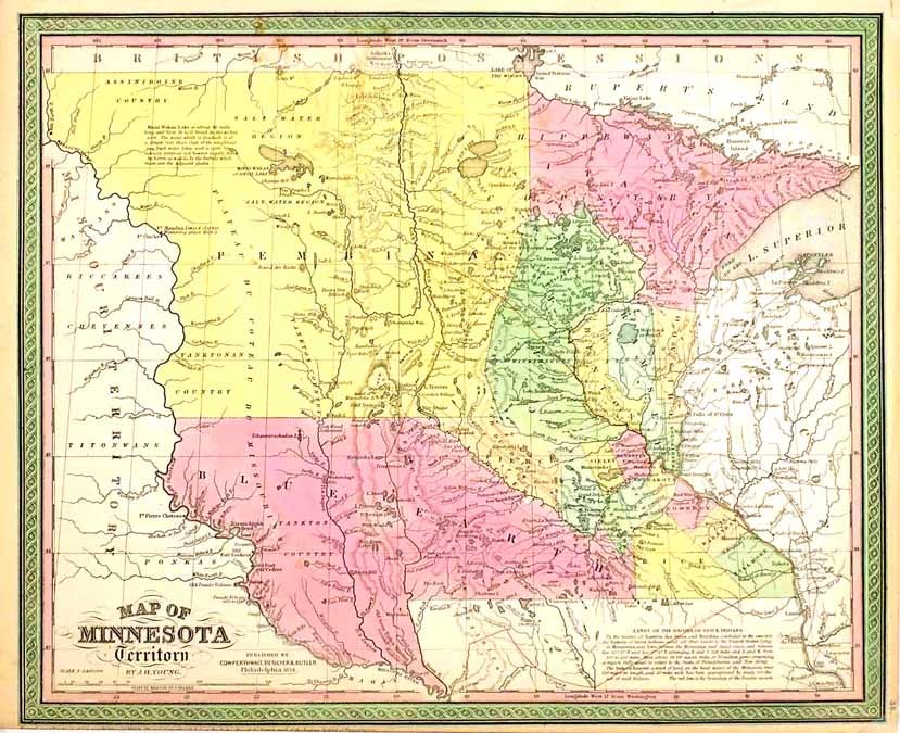
NP: NP, 1850 (but later. 13 x 16. Minnesota Territory was created in 1849 and this early map shows it from Wisconsin in the east to the Missouri River in the west, thus encompassing much of what would become Dakota. Some counties appear, but the only ones that look like they're serious are on the lower Mississippi from Minneapolis-St. Paul to the southern boundary. In the far west two immense counties - Pembina and Blue Earth - are clearly governmental entities in name only. Little but waterways, lakes and Indian tribes are named in this empty region, although even at this late date Ft. Mandan as "Lewis & Clarkes wintering place 1804-5" is noted. Civilization is clearly on its way, though; a paragraph of text reads: "By the treaties of Traverse des Sioux and Mendota concluded in the year 1851 the Dakota or Sioux Indians ceded all their lands to the United StatesÉ Area about 54,100 square miles, or 35 million acres comprising a region fully equal in extent to the States of Pennsylvania and New Jersey. The Dakota Reserve, a tract of land on the head waters of the Minnesota river 120 miles in length, and 20 miles wide, has been appropriated by treaty for the use of said Indians." (Do the math.) A red line marks the boundary of this remarkable land swap. Counties are hand colored. A touch of browning, and the margin is close on the bottom shaving away a portion of the copyright information. Item #26538
Price: $250.00