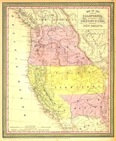
Map of the State of California, the Territories of Oregon & Utah, and the chief part of New Mexico.
NP: NP, 1850. 15.5x12.5. The first edition of this early atlas map of the west appeared in Mitchell's Universal Atlas in 1846 and it was continuously updated for many years thereafter. This is a particularly scarce variant with much of interest. It shows the west just after the Mexican War and the discovery of gold in California; thus, the boundary with Mexico is at the Gila River prior to the Gadsden Purchase of 1853, and the GOLD REGION is named across the Sacramento Valley yet with few towns named other than Marysville. There are no counties named (they would appear in the next year's edition), the Great Basin here is Fremont Basin, and Bonpland L. is the name of today's Lake Tahoe. Lewis and Clark's route is named as is the "Great Spanish Trial from P[ueblo] Angeles to Santa Fe," and many Indian tribes are named. Clearly the cartographer was trying to fill out the interior of the west as best he could, but the impression is still one of vast empty spaces. There are but four vast states and territories west of the continental divide, hand colored. The sheet is evenly browned, a stray wrinkle is visible in the right light, else a very good copy. Wheat Mapping the Trans-Mississippi West 725, Wheat Maps of the California Gold Region 201. Item #26531
Price: $850.00