
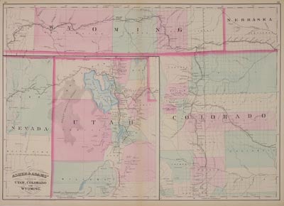
Asher & Adams' Portions of Utah, Colorado and Wyoming.
N/P: N/P, 1872. 16 x 22.5. The Asher & Adams atlas of 1872 was one of the first to feature railroad lines, showing minimal topography and few towns that are not on or near railroads. Hre is an excellent example of the A&A focus on railroads which additionally shows how sometimes their maps have configurations that are just...odd. Shown here is the front range of Colorado south to just include Walsenburg and west as far as Georgetown. The southern quarter of Wyoming appears almost to the western boundary. As mentioned, railroads dominate. The Union Pacific crosses Wyoming, the Kansas Pacific goes to Denver, the Denver Pacific runs from Cheyenne to Denver, and the Denver & Rio Grande goes from Denver only to Pueblo at this time. At the bottom left is another map - at 11 1/2 by 12 1/2 inches it is too big to call it an inset - of northwestern Utah. Again railroads are prominent with the UP entering from the east and the Central Pacific from the west. The Utah Central goes from Ogden through Salt Lake City to Provo City and on to Payson. Atypically, many towns are named that are not on the railroad. Hand colored with soft pastels characteristic of Asher & Adams. Center fold as issued, else very good. Item #26305
Price: $195.00